

 Toll Free 1800 572 9282
  mailus@wbcsmadeeasy.in


Bottom Topography Of Ocean Basins – Geography Notes – For W.B.C.S. Examination.
সমুদ্রের অববাহিকার নীচের টপোগ্রাফি – ভূগোল নোট – WBCS পরীক্ষা।
The relief features of the oceans are quite different from the continental features because the Oceanic crust is less than 60-70- million years old whereas continental features are of Proterozoic age (Over 1 Billion years old). Here, we are giving easy-to-learn write-up on the Oceanic topography along with typology and significance that will enhance the knowledge of aspirant who are preparing for different competitive exams.Continue Reading Bottom Topography Of Ocean Basins – Geography Notes – For W.B.C.S. Examination.
Water covers 70% of the earth’s surface in which only 3% are fresh water (Of this, 2% is in polar ice caps and only 1% is usable water). Oceans make up around 67 percent of the Earth’s surface. The relief features of the oceans are quite different from the continental features because the Oceanic crust is less than 60-70- million years old whereas continental features are of Proterozoic age (Over 1 Billion years old). Here, we are giving easy-to-learn write-up on the Oceanic topography along with typology and significance that will enhance the knowledge of aspirant who are preparing for different competitive exams.
Typology of Oceanic Topography
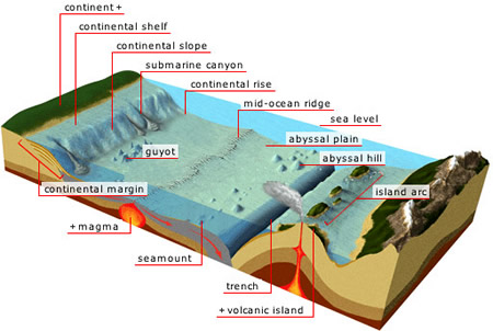
The Oceanic relief features are in the form of mountains, basins, plateaus, ridges, canyons and trenches beneath the ocean water. These forms are called Submarine Relief. The ocean relief can be divided into various parts such as Continental Shelf, Continental Slope, Continental Rise or Foot, Deep Ocean basins, Abyssal plains & Abyssal Hills, Oceanic Trenches, Seamounts and Guyots.
Continental Shelf
It is the submerged edge of a continent which is gently sloping plain. In other words, it is an extension of the continents into the ocean; continental shelf land would be exposed if sea level dropped. Siberian Shelf in the Arctic Ocean is the largest continental shelf in the world. It is made up of granite rock.
Continental Slope
It is the slope between the outer edge of the continental shelf and the deep ocean floor, which are lying between 2 degrees and 5 degrees.
Continental Rise or Foot
It connects the continental slope to the deep sea or abyssal plain which is around 100-1000 Km wide.
Deep Ocean Basins
It is the lowest layer in the Ocean, which is covered by the sediments of basalt up to 5 kilometres thick.
Abyssal Plains and Abyssal Hills
It is flat, cold and sediment covered ocean floor. They are more extensive in the Atlantic and Indian Oceans and less extensive in the Pacific Ocean.
Seamounts
It is elliptical projections from the sea floor, which look like mountains and have a steep slope of around 22 degree to 24 degrees.
Guyots
It is also known as a tablemount, is an isolated underwater volcanic mountain, with a flat top over 200 m below the surface of the sea. The diameters of these flat summits can exceed 10 km. It is inactive ocean volcanoes with flat top.
Significance of Oceanic Relief
1. It controls the motion of sea water.
2. It influences the oceanic movement in the form of currents.
3. It helps in the navigation and fishing.
In the above write-up on the Oceanic topography along with typology and significance will enhance the general knowledge of the readers.
Our own publications are available at our webstore (click here).
For Guidance of WBCS (Exe.) Etc. Preliminary , Main Exam and Interview, Study Mat, Mock Test, Guided by WBCS Gr A Officers , Online and Classroom, Call 9674493673, or mail us at – mailus@wbcsmadeeasy.in
Visit our you tube channel WBCSMadeEasy™ You tube Channel
Please subscribe here to get all future updates on this post/page/category/website