


 Toll Free 1800 572 9282
  mailus@wbcsmadeeasy.in


Climatology – Latitudes And Longitudes – Geography Notes For – W.B.C.S. Examination.
জলবায়ুবিদ্যা – অক্ষাংশ এবং দ্রাঘিমাংশ – ভূগোল নোট – WBCS পরীক্ষা।
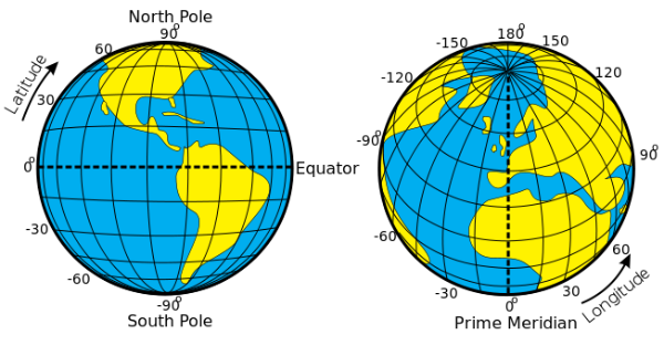
- Latitudes and Longitudes are imaginary lines used to determine the location of a place on earth.
- The shape of the earth is ‘Geoid’. And the location of a place on the earth can be mentioned in terms of latitudes and longitudes.Continue Reading Climatology – Latitudes And Longitudes – Geography Notes For – W.B.C.S. Examination.
- Example: The location of New Delhi is 28° N, 77° E.
Latitude
- Latitude is the angular distance of a point on the earth’s surface, measured in degrees from the center of the earth.
- As the earth is slightly flattened at the poles, the linear distance of a degree of latitude at the pole is a little longer than that at the equator.
- For example at the equator (0°) it is 68.704 miles, at 45° it is 69.054 miles and at the poles it is 69.407 miles. The average is taken as 69 miles (111km).
- 1 mile = 1.607 km.
Important parallels of latitudes
- Besides the equator (0°), the north pole (90°N) and the south pole (90° S), there are four important parallels of latitudes–
- Tropic of Cancer (23½° N) in the northern hemisphere.
- Tropic of Capricorn (23½° S) in the southern hemisphere.
- Arctic circle at 66½° north of the equator.
- Antarctic circle at 66½° south of the equator.
Latitudinal Heat zones of the earth
- The mid-day sun is exactly overhead at least once a year on all latitudes in between the Tropic of Cancer and the Tropic of Capricorn. This area, therefore, receives the maximum heat and is called the torrid zone.
- The mid-day sun never shines overhead on any latitude beyond the Tropic of Cancer and the Tropic of Capricorn. The angle of the sun’s rays goes on decreasing towards the poles. As such, the areas bounded by the Tropic of Cancer and the Arctic circle in the northern hemisphere, and the Tropic of Capricorn and the Antarctic circle in the southern hemisphere, have moderate temperatures. These are, therefore, called temperate zones.
- Areas lying between the Arctic circle and the north pole in the northern hemisphere and the Antarctic circle and the south pole in the southern hemisphere, are very cold. It is because here the sun does not raise much above the horizon. Therefore, its rays are always slanting. These are, therefore, called frigid zones.
Longitude
- Longitude is an angular distance, measured in degrees along the equator east or west of the Prime (or First) Meridian.
- On the globe longitude is shown as a series of semi-circles that run from pole to pole passing through the equator. Such lines are also called
- Unlike the equator which is centrally placed between the poles, any meridian could have been taken to begin the numbering of longitude. It was finally decided in 1884, by international agreement, to choose as the zero meridian the one which passes through the Royal Astronomical Observatory at Greenwich, near London.
- This is the Prime Meridian (0°) from which all other meridians radiate eastwards and westwards up to 180°.
- As the parallels of latitude become shorter poleward, so the meridians of longitude, which converge at the poles, enclose a narrower space.
- They have one very important function, they determine local time in relation to G.M.T. or Greenwich Mean Time, which is sometimes referred to as World Time.
Longitude and Time
- Since the earth makes one complete revolution of 360° in one day or 24 hours, it passes through 15° in one hour or 1° in 4 minutes.
- The earth rotates from west to east, so every 15° we go eastwards, local time is advanced by 1 hour. Conversely, if we go westwards, local time is retarded by 1 hour.
- We may thus conclude that places east of Greenwich see the sun earlier and gain time, whereas places west of Greenwich see the sun later and lose time.
- If we know G.M.T., to find local time, we merely have to add or subtract the difference in the number of hours from the given longitude.
Standard Time and Time Zones
- If each town were to keep the time of its own meridian, there would be much difference in local time between one town and the other.
- Travelers going from one end of the country to the other would have to keep changing their watches if they wanted to keep their appointments. This is impractical and very inconvenient.
- To avoid all these difficulties, a system of standard time is observed by all countries.
- Most countries adopt their standard time from the central meridian of their countries.
- In larger countries such as Canada, U.S.A., China, and U.S.S.R, it would be inconvenient to have single time zone. So these countries have multiple time zones.
- Both Canada and U.S.A. have five time zones—the Atlantic, Eastern, Central, Mountain and Pacific Time Zones. The difference between the local time of the Atlantic and Pacific coasts is nearly five hours.
- S.S.R had eleven time zones before its disintegration. Russia now has nine time zones.
The International Date Line
- A traveler going eastwards gains time from Greenwich until he reaches the meridian 180°E, when he will be 12 hours ahead of G.M.T.
- Similarly in going westwards, he loses 12 hours when he reaches 180°W. There is thus a total difference of 24 hours or a whole day between the two sides of the 180° meridian.
- This is the International Date Line where the date changes by exactly one day when it is crossed. A traveler crossing the date line from east to west loses a day (because of the loss in time he has made); and while crossing the dateline from west to east he gains a day (because of the gain in time he encountered).
- The International Date Line in the mid-Pacific curves from the normal 180° meridian at the Bering Strait, Fiji, Tongaand other islands to prevent confusion of day and date in some of the island groups that are cut through by the meridian.
- Some of them keep Asiatic or New Zealand standard time, others follow the American date and time.
Why is the international dateline drawn in a zigzag manner?
- The International Date Line (IDL) passes through the Pacific Ocean. It is an imaginary line, like longitudes and latitudes.
- The time difference on either side of this line is 24 hours. So, the date changes as soon as one crosses this line.
- Some groups of Islands (Polynesia, Melanesia, Micronesia) fall on either of the dateline. So if the dateline was straight, then two regions of the same Island Country or Island group would fall under different date zones. Thus to avoid any confusion of date, this line is drawn through where the sea lies and not land. Hence, the IDL is drawn in a zig-zag manner.
Indian Standard Time
- The Indian Government has accepted the meridian of 82.5° east for the standard time which is 5 hours 30 mins, ahead of Greenwich Mean Time.
Chaibagaan Time
- 150 years ago British colonialists introduced “chaibagaan time” or “bagaan time”, a time schedule observed by tea planters, which was one hour ahead of IST.
- This was done to improve productivity by optimizing the usage of daytime.
- After Independence, Assam, along with the rest of India, has been following IST for the past 66 years.
- The administration of the Indian state of Assam now wants to change it’s time zone back to Chaibagaan time to conserve energy and improve productivity.
- Indian government didn’t accept to such a proposal.
Our own publications are available at our webstore (click here).
For Guidance of WBCS (Exe.) Etc. Preliminary , Main Exam and Interview, Study Mat, Mock Test, Guided by WBCS Gr A Officers , Online and Classroom, Call 9674493673, or mail us at – mailus@wbcsmadeeasy.in
Visit our you tube channel WBCSMadeEasy™ You tube Channel
Please subscribe here to get all future updates on this post/page/category/website