

 Toll Free 1800 572 9282
  mailus@wbcsmadeeasy.in


W.B.C.S. Examination Notes On – Geology – Paleoclimate.
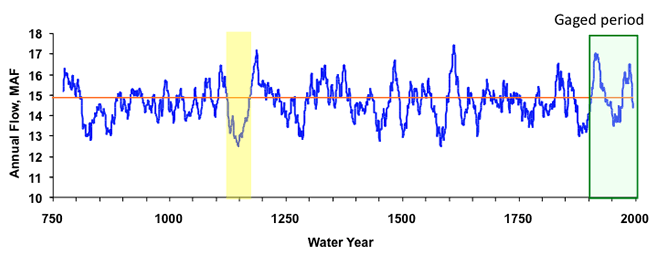
Geology a branch of Earth Sciences, has risen as one of the most secure and scoring optional subject for the W.B.C.S. Civil Services Mains examination. This subject is easy to understand, hence easy to crack. So, if the aspirants have profound interests in geology, then choose this subject. The syllabus of geology for W.B.C.S. Mains exam is long and aspirants may require over three months covering the syllabus.Paleoclimate reconstructions are most often made based on data from a single location. Interpretation of the climatic changes at a given study location, however, depends on knowledge about other places – perhaps even the rest of the world. Maps of paleoclimate data therefore are the ultimate reconstructions.Continue Reading W.B.C.S. Examination Notes On – Geology – Paleoclimate.
They show empirically based representations of past climate gradients, which can be used to infer circulation patterns and other important dynamics (e.g., CLIMAP Project Members, 1981; COHMAP Members, 1988; Mann et al., 1998). Such inferences are limited if made from single proxy records alone, and like all paleoclimate reconstruction, can be made using qualitative or quantitative approaches. Qualitative approaches include either (1) inferring synoptic dynamics from climatic patterns (e.g., Shuman et al., 2002) or (2) finding a modern analog amid historic climate data that shows a pattern similar to the inferred past climate pattern (e.g., Mock and Brunelle-Daines, 1999). Quantitative approaches involve either (1) using statistical linkages between climatic values and synoptic climate dynamics (e.g., Webb and Bryson, 1972) or (2) comparing the data with climate model output (e.g., COHMAP Members, 1988).
Like the real-climate system, climate models produce fields of data that represent the spatial gradients of temperature, precipitation, pressure, and wind, as well as other variables (Bartlien and Hostetler, 2004). Comparisons of model output with maps of paleoclimate data thus provide important insights, which benefit both the quest to improve climate models and to better understand past-climate dynamics. The comparisons reveal the ability of the model to accurately simulate conditions unlike those found today and show the types of dynamics that may explain past climate patterns (COHMAP Members, 1988). Therefore, in combination with climate model output, the paleoclimate record offers a rich source of insight into conditions unlike those experienced today.
Paleoclimate modelers attempt to model ancient climates by applying numerical models to large proxy data sets, such as pollen spectra from terrestrial sites or foraminifera from ocean sediments. These are difficult undertakings because hundreds of data sets must be assessed for their reliability. The chronologies of the many data sets are always difficult to reconcile, but this is an essential aspect of paleoclimate modeling.
The PMIP (The Paleoclimate Modeling Intercomparison Project) project is an outstanding example of paleoclimate modeling. The project involves modeling groups from the United States, Canada, United Kingdom, Germany, France, Australia, Japan, and Korea (Joussaume and Taylor, 1995). The aims are to evaluate climate models under paleoclimate conditions and improve our understanding of past climate. In the first phase, boundary conditions were defined and models simulations were completed. The group participants have met every 2 years since 1995 in order to discuss the results and form working groups that concentrate on specific problems. Three PMIP modeling experiments have been defined: one for the mid-Holocene (6000 years BP) and two for the last glacial maximum (LGM), (21,000 years BP). The models attempt to reconstruct either with atmosphere alone models or with atmosphere models coupled with surface ocean models.
One of the more intriguing modeling projects was the Pliocene Research, Interpretation, and Synoptic Mapping (PRISM) project (Dowsett et al., 1996). A major component of the PRISM project was the systematic documentation of the magnitude and variability of middle Pliocene SSTs on a global scale. The project aimed to provide a conceptual model and synoptic view of the earth during an interval considerably warmer than modern, and the middle Pliocene represents the last interval of earth history when this was the case, and when other climate boundary conditions (i.e., position of continents, fauna and flora, etc.) were essentially unchanged.
The middle Pliocene PRISM SST reconstruction shows a uniform pattern of little or no difference from modern in equatorial regions with warmer conditions at middle and higher latitudes. An enhanced greenhouse effect and increased oceanic heat transport are the two primary mechanisms that have been proposed to explain warmer climates.
Please subscribe here to get all future updates on this post/page/category/website