

 +919674493673
  mailus@wbcsmadeeasy.in


Geology Notes On – Vindhyan Basin – Notes For W.B.C.S. Examination.
ভূতত্ত্ব নোট – বিন্ধ্য পর্বতের অববাহিকা – WBCS পরীক্ষা।
The Vindhyan basin is a classic example of Proterozoic intracontinental basin thatdeveloped in the central part of the Indian shield along with several other basins such asCuddapah, Chattisgarh, etc. The strata are exposed in three major sectors: Son valley,Bundelkhand and Rajasthan. Substantially thick Vindhyan rocks have also been recognizedunder the Gangetic alluvium.Continue Reading Geology Notes On – Vindhyan Basin – Notes For W.B.C.S. Examination.
The Vindhyan Basin, containing more than 5000 m thick sequence of sandstones, shalesand limestones, occupies an area of about 1,62,000 sq.km of which about 80,000 Sq.kmextends into the Ganga valley in the north and northeast beneath the Tertiary sediment ofthe Himalayan foredeep. In the southwest, the Vindhyan rocks are covered by Deccan
volcanics.
Tectonic Framework:
The basin is bounded by the Son-Narmada Geofracture in the south, the Great BoundaryFault in the west, the Monghyr-Saharsa Ridge in the east, and the Bundelkhand Massifand Indo-Gangetic Plains in the north. Bundelkhand Massif divides this basin into two
parts – the Son Valley on the southeastern side and the Chambal Valley where exposuresoccur from Agra (Uttar Pradesh) to Chittorgarh (Rajasthan).The southern margin of the Vindhyan basin is marked by a major ENE–WSW trending.
Basin Evolution:
The Vindhyan Basin was formed as a result of a large crustal downwarp in the northernpart of the Indian Platform, after the Delhi orogeny. The initial transgression of the seafrom the north is inferred to have taken place in the eastern part of the basin over the
Bijawars. The shallow sea appears to have established lagoonal conditions near the coastalpart during the subsequent regressive phase. Initially, the Son-Narmada Lineament wasdormant, but at the onset of Vindhyan sedimentation later, the fault system along this downwarp became active with the formation of the southern limit of Vindhyan deposition.
After the deposition of Kajrahat Limestone, the Son-Narmada Lineament again becameactive resulting in emission of volcanic material, which was deposited as the JardepaharPorcellanite. In the subsequent regression, the shore line shifted towards northwest. TheFawn Limestone was deposited over the shelf in a tidal flat environment. This wasfollowed by shallowing of the basin as is evident from the overlying Glauconitic Sandstone.The fresh marine transgression resulted in the deposition of marine shales followed by
Rohtas Limestone.
Stratigraphy:
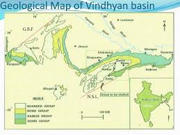
The entire Vindhyan succession, maximum thickness estimated to be around 3 km, andcomprising mainly sandstone, shale and limestone is assigned as the Vindhyan Supergroup.The Supergroup is divisible into four groups:
Semri Group,
Kaimur Group,
Rewa Group and
Bhander Group
from bottom to top. Each group is again subdivided into several formations. The SemriGroup in the Son valley rests unconformably on a variety of pre-Vindhyan rocks such asgranites and metamorphics. In the Bundelkhand area, the group overlies the Bundelkand
Granite Gneisses and Bijawar Group of metamorphics, whereas in the southern Son valley,Mahakoshal is the basement in most places; however, in some localities (e.g., Deoland,M.P.) the basement is granite. The Semri succession of the Bundelkhand area has two detached outcrops around Chitrakut and Bijawar respectively, and is only a few tens ofmeters thick.
Exploration Status:
GSI mapped 23,690 sq km area, 400 core samples and 1360 rock samples analysed forsource rock potential. ONGC acquired Gravity-Magnetic data at 11464 stations. NGRI alsoconducted DSS (Deep Seismic Sounding) survey from Hirapur over Bundelkhand Massif to
Mandla, south of Jabalpur. Aeromagnetic survey to the tune of 59,771 LKM have also been carried out in this basin.
CDP reflection survey covering 6802 LKM has been conducted by ONGC. Further, DGH and Alphageo (India) Limited carried out CDP vibroseis reflection survey amounting to566 LKM. Aeromagnetic survey to the tune of 59,771 LKM have also been carried out in
this basin.
Exploratory Drilling
Three exploratory wells namely, Jabera-1, Damoh-1 and Kharkhari-1 have been drilled in this basin. The well Jabera-1 has been drilled to a depth of 3597.70 m. The well Damoh-1 has been drilled to a depth of 3501 m. However, no indications of hydrocarbon
were obtained.
Our own publications are available at our webstore (click here).
For Guidance of WBCS (Exe.) Etc. Preliminary , Main Exam and Interview, Study Mat, Mock Test, Guided by WBCS Gr A Officers , Online and Classroom, Call 9674493673, or mail us at – mailus@wbcsmadeeasy.in
Visit our you tube channel WBCSMadeEasy™ You tube Channel
Please subscribe here to get all future updates on this post/page/category/website